Barrow Surveying and Mapping
In 1979, Luther Barrow, Jr., PLS, started Barrow Surveying and Mapping in the back room of his home. Later that year, the business was moved to Snow Hill, NC, across the street from the courthouse. Barrow Surveying and Mapping specialized in residential and farm surveys in Greene County.
Expansion
In 1994, the business was incorporated as Barrow & Barrow, PA and then, in 2004, moved to its present location at 115 Heritage Crossing in Snow Hill. The business is now operated by Steve Barrow, PLS and Darryl Barrow, PLS, with Luther as a consultant.
Today
 The scope of services offered has now expanded to include residential and commercial planning and site design, subdivision development, erosion and sediment control and low-density storm water drainage, environmental and mining surveys, and site layout. A full range of drafting services is offered using the latest versions of AutoCAD, Carlson Civil Suite and Photoshop.
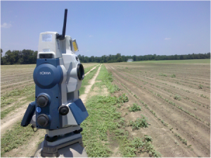
Barrow & Barrow, PA uses state-of-the-art equipment including Topcon Total Stations, Sokkia Robotic Total Stations and Global Positioning Systems(GPS). Barrow purchased one of the first five Topcon Hiperlite+ Global Positioning Systems sold in the United States. With the emphasize now on computerization, Darryl, with a degree from ECU in Computer Science, keeps Barrow & Barrow, PA on the cutting edge with the newest technology, training and service. A survey can now be produced from field to finished map without using a pen or pencil.
Barrow & Barrow, PA
What does this mean to the client? It means three generations of knowledge about the people and properties of Greene County. It means a precision survey in a timely manner. It means good service with the product delivered on time at a fair price. Barrow & Barrow, PA is the oldest survey firm in Greene County. Using the newest technology, being service oriented and offering fair prices, Barrow & Barrow, PA would like to remain Greene County’s surveyor of choice for generations to come.
